Ships' routeing

The practice of following predetermined routes for shipping originated in 1898 and was adopted, for reasons of safety, by shipping companies operating passenger ships across the North Atlantic. Related provisions were subsequently incorporated into the original SOLAS Convention.
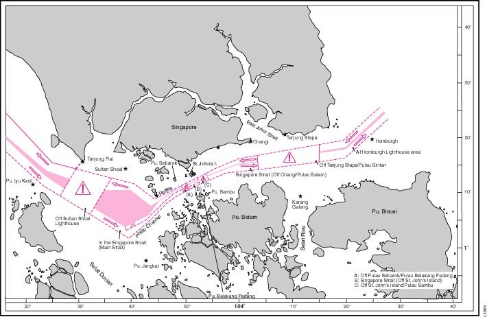
Traffic separation schemes and other ships' routeing systems have been established in most of the major congested, shipping areas of the world, and the number of collisions and groundings has often been dramatically reduced.
IMO's responsibility for ships' routeing
IMO's responsibility for ships' routeing is enshrined in SOLAS chapter V, which recognizes the Organization as the only international body for establishing such systems.
Rule 10 of the COLREG prescribes the conduct of vessels when navigating through traffic separation schemes adopted by IMO.
IMO's responsibilities are also determined under the United Nations Convention on Law of The Sea (UNCLOS), which designates IMO as "the competent international organization" in matters of navigational safety, safety of shipping traffic and marine environmental protection.
Governments intending to establish a new routeing system for IMO's adoption, or amend an existing one, should submit proposed routeing measures to the IMO's Sub-Committee on Navigation, Communications and Search and Rescue (NCSR), which will then evaluate the proposal and make a recommendation regarding its adoption by the Maritime Safety Committee.
Ships' routeing measures adopted by IMO to improve safety of navigation at sea include, for example:
- traffic separation schemes;
- two-way routes;
- recommended tracks;
- deep water routes (for the benefit primarily of ships whose ability to manoeuvre is constrained by their draught);
- precautionary areas (where ships should navigate with particular caution);
- areas to be avoided (for reasons of exceptional danger or especially sensitive ecological and environmental factors).
IMO publication "Ships' Routeing "
Ships' routeing measures adopted by IMO are contained in the IMO publication
Ships' Routeing, which is regularly updated.
The publication includes general provisions on ships' routeing, which are aimed at standardizing the design, development, charted presentation and use of routeing measures adopted by IMO. The provisions state that the objective of ships' routeing is to "improve the safety of navigation in converging areas and in areas where the density of traffic is great or where freedom of movement of shipping is inhibited by restricted searoom, the existence of obstructions to navigation, limited depths or unfavourable meteorological conditions".
Elements used in ships' routeing systems
Elements used in ships' routeing systems include:
- traffic separation scheme: a routeing measure aimed at the separation of opposing streams of traffic by appropriate means and by the establishment of traffic lanes
- traffic lane: an area within defined limits in which one-way traffic is established. natural obstacles, including those forming separation zones, may constitute a boundary
- separation zone or line: a zone or line separating traffic lanes in which ships are proceeding in opposite or nearly opposite directions; or separating a traffic lane from the adjacent sea area; or separating traffic lanes designated for particular classes of ship proceeding in the same direction
- roundabout: a separation point or circular separation zone and a circular traffic lane within defined limits
- inshore traffic zone: a designated area between the landward boundary of a traffic separation scheme and the adjacent coast
- recommended route: a route of undefined width, for the convenience of ships in transit, which is often marked by centreline buoys
- deep-water route: a route within defined limits which has been accurately surveyed for clearance of sea bottom and submerged articles
- precautionary area: an area within defined limits where ships must navigate with particular caution and within which the direction of flow of traffic may be recommended
- area to be avoided: an area within defined limits in which either navigation is particularly hazardous or it is exceptionally important to avoid casualties and which should be avoided by all ships, or by certain classes of ships
See also:
MSC/Circ.1060, as amended - Guidance note on the preparation of proposals on ships' routeing systems and ship reporting systems.
Proposals on ships' routeing and ship reporting systems by Governments
Templates are available for proposals on ships' routeing and ship reporting systems to be submitted to the NCSR Sub-Committee.
These can be obtained by sending an e-mail to the Secretariat of the NCSR Sub-Committee.
RELATED TOPIC
Weather routeing
Weather conditions can also affect a ship's navigation, and in 1983 IMO adopted resolution A.528(13) on Recommendation on Weather Routeing, which recognizes that weather routeing - by which ships are provided with "optimum routes" to avoid bad weather - can aid safety. It recommends Governments to advise ships flying their flags of the availability of weather routeing information, particularly that provided by services listed by the World Meteorological Organization.
Further information
SOLAS regulations V/10 (Ships' routeing) and V/11 (Ship reporting systems)
MSC.1/Circ.1060, as amended - Guidance note on the preparation of proposals on ships' routeing reporting systems
MSC.1/Circ.1608 - Procedure for the submission of documents containing proposals for the establishment of, or amendments to, ships' routeing systems or ship reporting systems
Historical background on Ships' Routeing